Please visit this project at
WisDOT’s new Projects Hub site, and adjust bookmarks as needed. The site content below will be archived later this year.
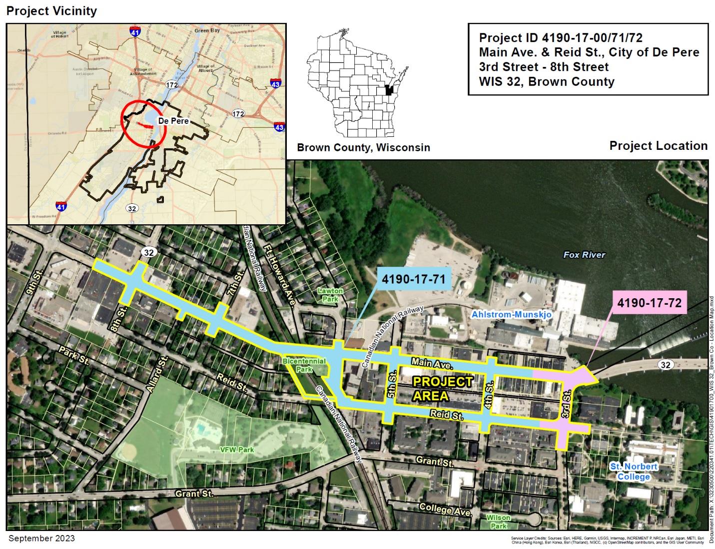
The Wisconsin Department of Transportation (WisDOT) Northeast Region is investigating and developing alternatives for proposed improvements on 0.7 miles of WIS 32 in the city of De Pere, Brown County.
Project location
WIS 32 west of the Fox River in the city of De Pere between Eighth Street and the Claude Allouez Bridge.
Public involvement meeting #4
WisDOT held a public meeting on October 21, 2025 to review project updates, plan refinements, and anticipated construction staging. All information shared at the public meeting is contained on this website and in the public handout and PowerPoint below.
Project updated designs (October 2025)
The below project updates have PowerPoint display slides noted next to each design update and text. Please review the PowerPoint slide number that corresponds to each design update noted below.
The design refinements noted at the October 2025 are below:
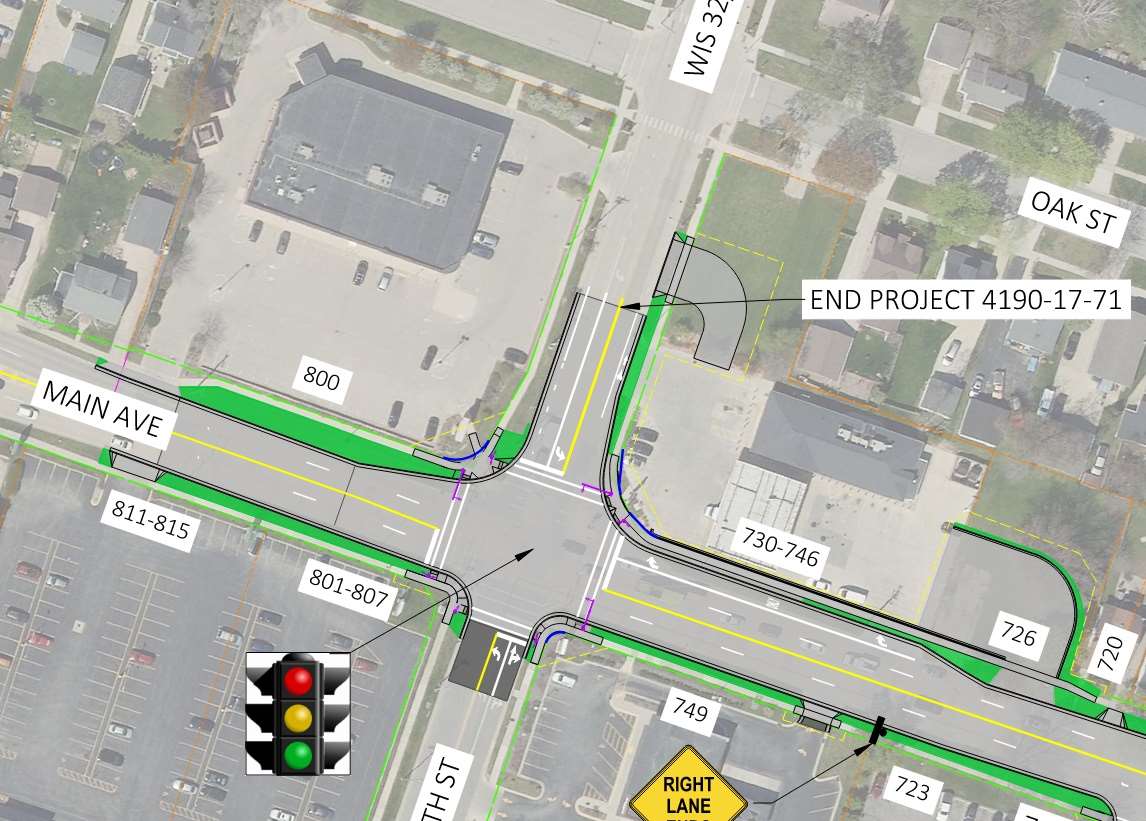
Geometric updates to the intersection of Eighth Street and Main Avenue - Slide 8: The major change from existing conditions at the intersection is modifications to the westbound to northbound right turn lane, including removal of the existing pork chop island, lengthening the westbound to northbound right turn lane and relocation of the Kwik Trip driveways further away from the intersection.
Eastbound Main Avenue lane drop after Seventh Street - Slide 9: To provide more advance warning of the lane drop to drivers, the signing and pavement marking will be improved. This will include additional signing and a dotted line in advance of the lane drop versus the current long dash lane line.
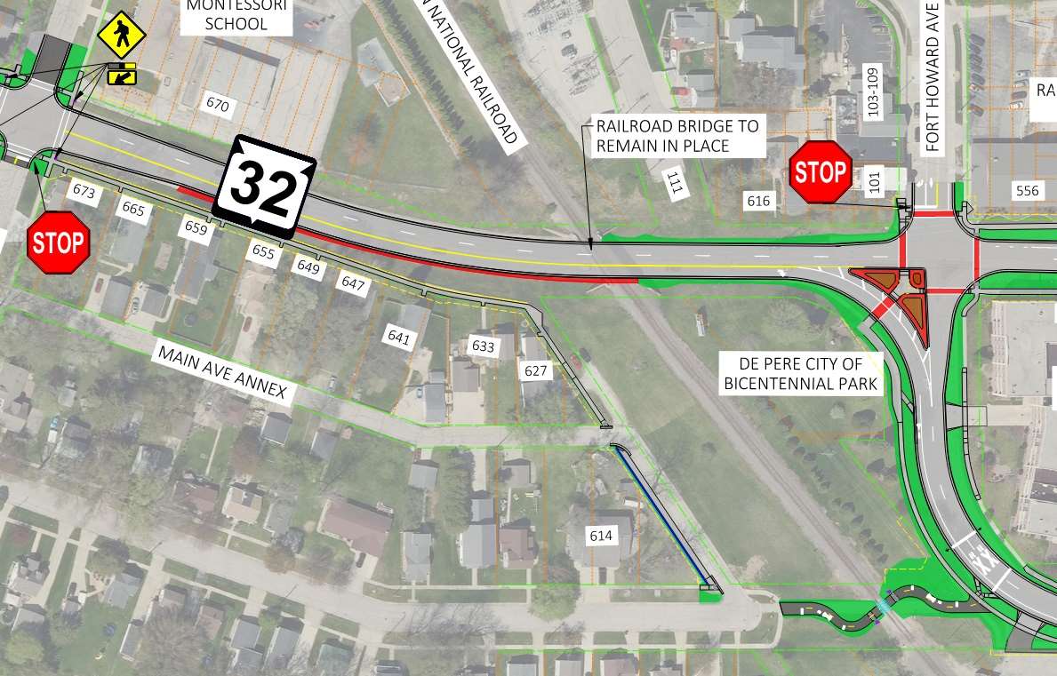
Reid Street Path and Pedestrian Reroute - Slide 10: The existing sidewalk on the south side of Main Avenue from Seventh Street to Fort Howard will be removed and pedestrians will be rerouted above to the sidewalk along the Main Ave Annex to Reid Street. The existing sidewalk and railing will be replaced. Temporary limited easements and a small amount of right-of-way will be required to construct the ADA-compliant sidewalk and curb ramps. Also, the path across the railroad will be reconstructed with new signals.
Geometric updates in the 500 block of Main Avenue - Slide 11. Updates include:
- Reconfiguration of the Fort Howard Intersection and island
- Narrowing of Main Avenue west of the at-grade railroad crossing
- Removal of the existing sign bridge
- Addition of railroad signals and gates at the at-grade railroad crossing
- Removal of the curb opening from the Nicolet Condominiums parking lot
Geometric updates in the 400 block of Main Avenue - Slide 12. Updates include:
- Addition of curb bump outs at the Fifth Street intersection
- Addition of curb bump outs at the Fourth Street intersection
- Narrowing of the face-of-curb to face-of-curb street width to provide additional terrace space
- Delineating a 5-foot furniture zone between the 5-foot pedestrian access route and right-of-way line
- Removal of the existing driveway at 400 Main Avenue closest to Fourth Street
Geometric updates in the 300 block of Main Avenue - Slide 13. Updates include:
- Narrowing of the face-of-curb to face-of-curb street width to provide additional terrace space
- Delineating a 5-foot furniture zone between the 5-foot pedestrian access route and right-of-way line
- Replacement of the existing bricks in the terrace with colored and stamped concrete
 Geometric updates in the 500 block of Reid Street - Slide 14. Updates include:
- Narrowing of Reid Street west of the at-grade railroad crossing
- Addition of a bike lane on the west/south side of Reid Street
- Addition of railroad signals and gates at the at-grade railroad crossing
- Addition of a driveway to the Nicolet Condominiums parking lot
Geometric updates in the 400 block of Reid Street - Slide 15. Updates include:
- Addition of curb bump outs at the Fifth Street intersection
- Addition of curb bump outs at the Fourth Street intersection
- Addition of a bike lane on the south side of Reid Street
Geometric updates in the 300 block of Reid Street - Slide 16. Updates include:
- Addition of a bike lane on the south side of Reid Street
- Replacement of the existing bricks in the terrace with colored and stamped concrete
Third Street - Slide 17:
- The existing brick terrace will be replaced with colored and stamped concrete
Railroad crossings
The design at the at-grade railroad crossings along the project at Main Avenue and Reid Street continue to be investigated and refined. Below are
Rectangular Rapid Flashing Beacons (RRFBs) will be installed at the following locations:
- Main Avenue at Seventh Street
- Main Avenue mid-block crossing in the 300 block
- Main Avenue at Third Street
- Third Street free-flow, right turn onto the Claude Allouez Bridge
Community sensitive design (CSD): Additional opportunities for CSD are coordinated with local communities and available for the project. CSD elements provide communities the opportunity to further enhance the project aesthetics and the additional funding opportunities provide more options for communities. WisDOT is coordinating with the city of De Pere to determine what aesthetic elements will be incorporated into the project.
Project construction staging
The project is proposed to be constructed in five stages. The proposed construction staging can be found on the
Construction Staging webpage here.
Project FAQ
A Frequently Asked Question sheet is available for download. Please feel free to print and share.
Project purpose and need
The purpose of the project is to restore the ride quality of the existing deteriorated pavement and upgrade other roadway deficiencies on WIS 32 through the city of De Pere.
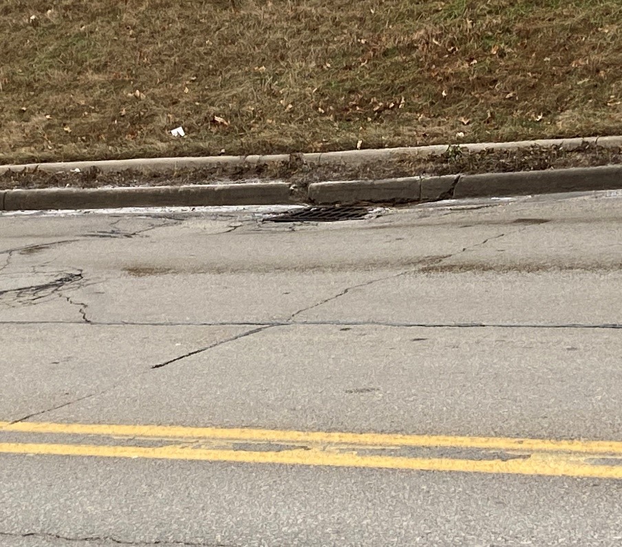
- Pavement at locations on WIS 32 in the project work zone have a Pavement Condition Index (PCI) as low as 21 out of 100. PCI is a measure of the roadway’s structural health. Individual pavement distresses are identified and calculated.
- Curb ramps are not compliant with the standards of the ADA.
Anticipated benefits
Specific benefits depend on the alternative selected. All alternatives include:
- Provide motorists with a smoother riding surface resulting in less wear on vehicles
- Decreased annual maintenance costs for the city, saving taxpayer dollars
- Improved accessibility for pedestrians by bringing the non-compliant curb ramps into compliance with ADA standards
- Replacement of the aging underground utilities prior to roadway paving
- Safety improvements at the at-grade railroad crossings
- Improved bike and pedestrian accommodations
Traffic impact overview
Traffic impacts during construction are still being developed.
- There will be long-term closures and detours during construction
- Access to businesses and properties would be maintained during construction
- A pedestrian detour for construction activities at the curb ramps and on sidewalks and crosswalks
- Anticipated closures and detour routes can be found on the
WIS 32 construction staging webpage
Schedule
- Investigation and evaluation of alternatives: 2022 - 2024
- Public Involvement Meeting #1: December 2022
- Public Involvement Meeting #2: October 2023
- Public Involvement Meeting #3: January 2025
- Public Involvement Meeting #4: October 2025
- Finalize Preliminary Design and Approve Environmental Document: Fall 2025
- Final Design: 2025 – 2027
- Real Estate Acquisition: 2026 - 2027
- Utility Reconstruction/Relocations: 2027
- Roadway construction currently scheduled to begin in 2028
Real estate
Real estate and right-of-way needs depend on the alternative selected. The real estate needs of the project will be better defined as the alternatives are developed and evaluated during this phase of the project.
Business Resource: WisDOT’s In This Together program
WisDOT recognizes businesses located in work zones or impacted by detour routes have special needs.
WisDOT's In This Together program is offered to businesses, organizations, and community leaders as an idea source as they plan for road construction in their area. It includes promotional examples, case studies, and a specially designed Business Coordination Guide with information on:
- Planning ahead
- Staying informed
- Keeping customers informed
- Tips for businesses
- Temporary signing for businesses with road closures
Public comments
Your comments assist us in developing a project that will serve the needs of the traveling public as well as the needs of the local community. All comments are welcomed and appreciated throughout the design process. Please submit comments to WisDOT using one of the following methods.
- Fill out the comment form with the prepaid mailer attached to the project handout
- Email comments or questions to the contacts listed below.
- Call the contacts below.
Project contacts
Joshua Lang, P.E., Project Manager
WisDOT Northeast Region
944 Vanderperren Way
Green Bay, WI 54304
(920) 492-4141
Joshua.Lang@dot.wi.gov
Mark Kantola, Communications Manager
Wisconsin Department of Transportation
944 Vanderperren Way
Green Bay, WI 54304
(920) 492-4153
mark.kantola@dot.wi.gov